

Introduction to web programming for GIS applications
BESTSELLER | Created by Michael Miller | Video: h264, 1280x720 | Audio: AAC 48KHz 2ch | Duration: 14:41 H/M | Lec: 103 | 1.69 GB | Language: English | Sub: English [Auto-generated]
https://www.udemy.com/course/introduction-to-web-programming-for-gis-applications/
Understanding web programming fundamentals focused on geospatial applications using Leaflet, Turf.js, and PostGIS
What you'll learn
Understand the basic technologies used in web programming and how they interact to form a web application. You will gain basic knowledge of HTML, CSS, JavaScript, jQuery, Bootstrap, PHP, AJAX, SQL, and the PostgreSQL database. More specifically you will gain enough understanding of these technologies to be able to use Leaflet, Turf.js, and PostGIS to create a web-mapping application that is freely available to all.
Requirements
This is an introductory level course. The focus is on understanding concepts and, although examples will be provided, installing software and following along is not expected.
Some familiarity with programming and GIS will be beneficial but it is not assumed.
Description
"Excellent overview of web programming with Geospatial data. I highly recommend this for any beginners. For those with more experience designing web applications, there are a number of points addressed that often are overlooked in typical tutorials. This was a great dive into using open source tools and provides a great example of the tools in action. " - Student Review on Udemy
"Thank you for this course! It fills a knowledge gap that I wasn't even aware I had. As a GIS scientist without formal computer science training, a lot of what you are teaching here will come in handy." - Student message on Udemy
"You truly have inspired me to take a step away and focus on learning more webGIS. Thanks!!" - Student comment on Twitter
"Michael is an incredibly knowledgeable instructor who assumes no prior knowledge. The course content builds up from some very basic coding practices to complex interaction between client and database via a server. Although it was not expected that the exercises were completed I did indeed follow along and now have a fully-functional webapp that I can modify to suit my needs. For an introduction, this course covers an incredibly wide range of concepts covering not only the display and processing of spatial data but also some internet security measures and even a little history thrown in which makes it much easier to understand the possibilities and limitations of Web GIS. I am thoroughly looking forward to starting Michael's Leaflet course." - Student Review on Udemy
"The course is exactly what I need -- not some copy the script and modify, but rather an understanding of what the process is. At this point, it sounds like a great overview and I am equally impressed with the background and teaching style of the instructor." - Student Review on Udemy
"Great course does exactly what it says on the tin! Easily digested bite sized lectures that are clear and concise and always put the learning into a geospatial perspective, just what I was looking for." - Student review on Udemy
This course is oriented towards achieving a conceptual understanding of how web technologies work together to form a web application that can be used to distribute, collect, or analyze geospatial data.
The focus will be on understanding concepts. You will not have to install any software on your computer. You will not be asked to follow along step-by-step. Instead the goal will be to provide the background information necessary to understand how the internet works, which technologies you really need to understand and when to use them. We will also explore additional technologies that you may want to explore further as your understanding and needs grow.
We will be using readily available open source software so you will be able to create web maps without spending any money. The concepts you will learn, however, will be equally valid if you have access to commercial GIS software and web servers.
My intention is to provide the information that I wish I had available before I began my journey into the world of geospatial web development. I spent a lot of time trying to put together the big picture from the detailed information that was available and I wasted a lot of time pursuing technologies that really were not necessary. My hope is to help you navigate the world of web development more efficiently than I did and that after taking this course you will be better prepared to take more detailed courses from myself or others.
Who this course is for?
Two main groups of students will benefit from this course. First will be GIS users who are interested in understanding how to distribute and collect data using the internet. Second will be web developers interested in adding geospatial applications to their toolkit.

DJordanMedia The Complete Editing Course Bundle Pack
2025-11-11 23:09:34
Luke Stackpoole – Photography Masterclass – Master The Art Of Photography
2025-11-11 18:14:10
77组电影外观Log/Rec709视频还原色彩分级调色Lut预设包Pixflow – Colorify Cinematic LUTs
2025-02-13 11:03:14

复古怀旧电影风格温暖色调索尼Sony S-Log3视频调色LUT预设ROMAN HENSE – LUTs 24 for Sony S-Log3
2025-02-13 11:01:09
JUAN MELARA – P6K2Alexa PowerGrade AND LUTs V2 GEN 5
2025-02-13 10:58:24
3DsMax建模插件集合:rapidTools v1.14+使用教程
2020-07-06 17:44:38

Proko-人体解剖高级付费版(中文字幕)256课
2020-12-21 18:34:01
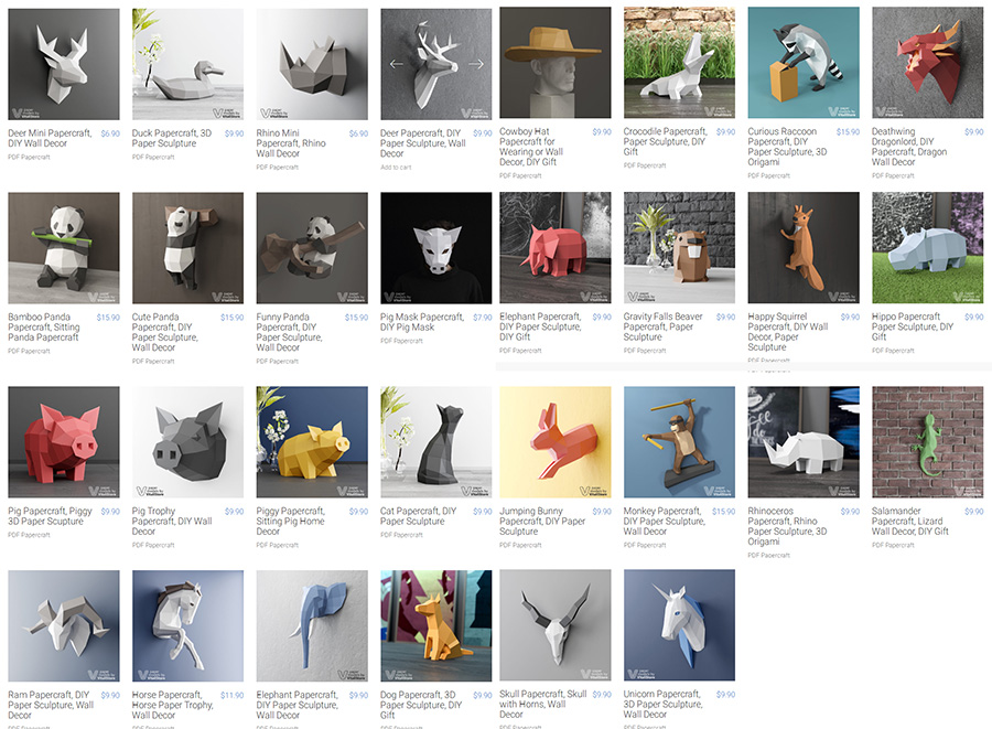
VitaliStore - All Design Bundle Papercraft Sculptures Design 动物纸模模型 纸模型雕塑设计
2020-07-21 17:18:14

小武拉莫日系摄影后期第二期中文视频教程
2021-12-10 14:26:14

Mod Portfolio 3477506 画册模板 时尚杂志画册模版
2020-07-13 10:43:06
小武拉莫日系摄影后期第二期中文视频教程
2021-12-10 14:26:14
VitaliStore - All Design Bundle Papercraft Sculptures Design 动物纸模模型 纸模型雕塑设计
2020-07-21 17:18:14

3DDD 3DSky PRO models – April 2021
2021-08-09 17:15:13

MasterClass 大师班课程84套合集+中文字幕+持续更新+赠品会员
2021-01-26 16:03:27
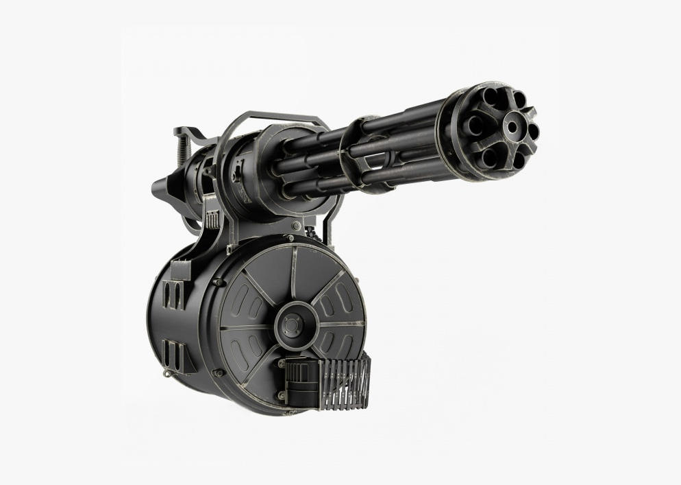
加特林机枪模型 加特林机关枪 Minigun Hi-Poly
2019-07-31 11:06:07

评论(0)